 |
|||||||||||||||||||||||||||||||||||||||||||||||||||||||||||||||||||||||||||||||||||
| INEGI MAPS & GEOGRAPHIC DATA | |||||||||||||||||||||||||||||||||||||||||||||||||||||||||||||||||||||||||||||||||||
|
Get the INEGI Maps and Cartgraphic information you need through BiciMapas BiciMapas is an authorized INEGI dealer which means you may get all the geographical and cartographical information it produces through us. Besides the already known topographic maps in the different scales available, now you can get vector and database information as explained below. So, do not hesitate to contact us to help you get your Mexican mapping solution. Map and Information Availability Consulting and Purchasing Process To purchase a map please use the following process : 1. Select the map(s) you want and the scale needed. Go to the About Mexican Topo Maps section for different options to search for the map you need. Should you need assistance, please contact us. 2. Contact us with the map information you need. We will verify availability and, estimated delivery time from INEGI after payment and shipping costs to you. We will send you this information by email. If the product you want is not listed just add comments explaining your needs. 3. Upon your acceptance of the prices, we will provide you with a link to a secure ordering and payment process through PayPal. 4. After we confirm your payment has been approved, we will order the product from INEGI and ship to you as soon as we get it.
PRODUCT INDEX
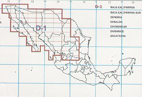
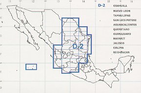
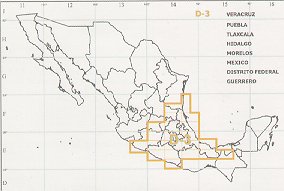
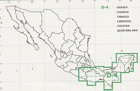
Topographic maps in paper and DRG formats For a general description of the INEGI maps please see the section About Mexican topo maps. We are able to help you with the following products: Digital 1:50,000 Maps. As of today (September 2004) about 75% of the country is available in this type of maps. This will be the preferred product if you choose this scale. If you order one, it may be sent through email. All other quantities will be supplied in a CD. Paper 1:50,000 Maps We will get you these maps only if the one you need is not available in Digital format. We believe there is no reason to buy a paper map if the digital version is available. If you need a paper version, just make a print of the digital one. These maps come in a set of 4 CDs for the whole country. Each CD covers a defined region may be sold separately. You can choose the one you need with this guide:
OziExplorer Georreferenced Products & Other Transformations We can provide all the digital maps already georreferenced and ready to use with Oziexplorer as well as perform projection, datum and file format transformations at a nominal additional cost.
OziExplorer Georreferencing
Datum, Projetion or File Format Transformation
These prices do not include shipping.
Vector Maps Map data in vector format is extensively used by GIS applications and is the source information to create custom GPS maps. INEGI produces this information in 1:250,000 and 1:50,000 in DXF format and for the most part is in NAD27 datum and UTM projection. The layers are as follows:
Urban Carthography Street information of Mexico's main cities in SHP and Mid/Mif formats.
Additional BiciMapas Services The following services are offered in conjunction with the associated INEGI product.
Terms 1. We will only order your maps from INEGI until your payment has been approved and completed. 2. Shipping costs will be quoted per shipment based on the address provided in the Map Request form and the cost shall be added to the product price. If we receive your order, the product will be shipped to that address. 3. Cancellations will only be accepted before ordering the product from INEGI. Once we order the product, all sales are final. 4. We are not responsible and shall not be held liable for the accuracy of the information contained in the maps. They are provided "as is". 5. You must respect INEGI´s copyrights. By ordering your maps from us, you accept and committ to respect these rights. 6. Delivery dates and timeframes will be estimated based on INEGI's availability feedback. You aknowledge and accept that there might be reasonable variations. 7. Upon ordering, you accept the charges made to your credit card and refuse any chargeback provided the product is delivered as promised. We will do our best to help you get your maps as fast as possible.
|


